Harvest Bans and Fire Control
Harvest & Vehicle Movement Bans
Harvest and Vehicle Movement Bans (HVMB) are issued by local governments and impact the whole local government area. These bans are put in place when conditions are such that the use of engines, vehicles, plant or machinery constitute high bushfire risk activities.
Bans are declared when readings of the following conditions are above a certain level:
- Wind
- Wind Gusts
- Humidity
- Temperature
- Fuel Loading/Curing
There is no time frame for a Harvest & Vehicle Movement Ban as conditions can change without warning so they are reviewed regularly.
Activities NOT PERMITTED during the period of this ban
- Harvesting operations are not permitted.
- Any "hot works" (eg. welding, grinding, cutting, heating etc.) in the "open air" are not permitted.
- Other - use or operation of any engine, vehicle, plant, equipment, or machinery in the area likely to cause a bush fire or contribute to the spread of a bush fire.
Activities PERMITTED during the period of this ban
- Use or operate any vehicle on gazetted roads, lanes, driveways, yards, or other areas that provide access to, or a parking facility at, any residential, farming or business premises, if the area has been sufficiently cleared of inflammable material to prevent the escape of fire.
- Use or operate a vehicle if it is for the prevention of an immediate and serious risk to the health or safety of a person or livestock, and only if all reasonable precautions have been taken to prevent the activity from creating a bush fire danger.
- Undertake essential feeding and watering of stock.
SMS Notifications
The Shire of Chapman Valley offers a free SMS text message alert service advising local residents when harvest and vehicle movement bans are imposed by the Chief Bushfire Control Officer and when the bans are lifted.
Local residents who wish to utilise this free service should complete the form below to register their mobile phone. Please note that a maximum of four (4) mobile phones per farm may be registered to receive the SMS alerts.
Completed forms must be returned to the Shire offices by email (cso@chapmanvalley.wa.gov.au).
SMS Alerts Register
Total Fire Bans
These are issued by the Department of Fire and Emergency Services (DFES) on days where a fire is most likely to threaten lives and property or if there are already widespread fires are firefighting resources are stretched. A Total Fire Ban (TFB) prohibits the lighting of any fires in the open air and any activities that may start a fire. Total Fire Bans affect everyone.
How do I know if a Total Fire Ban has been declared?
- Check the Emergency WA Website - https://www.emergency.wa.gov.au/
- Call the Total Fire Ban Hotline on 1800 709 355
- Call 13 DFES (133 337)
- Follow DFES on Facebook or Twitter
- Listen to ABC local radio or other media outlets
Can I drive a vehicle (4WD, motorbike or quad bike) where the vehicle will be in contact with vegetation during a Total Fire Ban?
No. During a Total Fire Ban you cannot use a vehicle off-road such as in the bush, paddock or any land which contains vegetation (alive or dead). You can only use a vehicle on a road, track or in an area which does not contain vegetation i.e. sand, clay.
There are exceptions where the activity is occurring as part of an agricultural activity, if the local government hasn't implemented a Harvest Vehicle Movement Ban during the Total Fire Ban.
There are also further exceptions for business, industry and public authorities, as long as the conditions prescribed in the Bush Fire Regulations 1954 are complied with, which include notifying DFES
Click on the below links for more information:
DFES Total Fire Ban Fact Sheet
Total Fire Ban - Department of Fire and Emergency Services
Fire Control
The Shire is divided into two Fire Control Zones, Zone 2 & Zone 4. Generally, Zone 2 affects that part of the Shire extending from Yuna to the east and north. The remainder of the shire is located in Zone 4. For the exact boundaries of the Fire Control Zones please consult the Senior Ranger:
Fire Danger Rating System
Shire of Chapman Valley residents are advised that the current Fire Danger Rating system changed to a new Australian Fire Danger Rating System (AFDRS) backed up by a new Fire Behaviour Index (FBI) on 1 September 2022.
The change will see ratings decrease from six to four and will be displayed in a uniform format on signage across the nation. Across the country fire and emergency services are applying nationally consistent colours, signs, and terminology. This means that wherever you go in Australia, and whatever the season or fuels you’re surrounded with, you can understand the level of threat and what you need to do to stay safe.
The current Fire Danger Rating System is largely based on science that is more than 60 years old.
New technology and research have greatly improved our ability to predict fire behaviour and the potential threat more accurately to the community. The new fire danger rating system is designed to be continuously up dateable so that the system can take advantage of and further improve science, data and information into the future.”
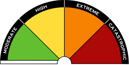
The AFDRS will have four levels with action-oriented messages to encourage people to take action. The ratings and high-level messages are:
- Moderate: Plan and prepare.
- High: Be ready to act.
- Extreme: Take action now to protect life and property.
- Catastrophic: For your survival, leave bushfire risk areas
Supporting messages, including localised information, will clearly explain what community response is required at each level.
The AFDRS also introduces an ‘off’ or ‘no rating’ level (white strip under Moderate) for days where no proactive action is required. This does not mean that fires cannot happen, but that they are not likely to move or act in a threatening way.
BENEFITS
The Australian Fire Danger Rating System (AFDRS) Program is redesigning the forecasting of fire by:
- Improving the scientific accuracy behind fire danger predictions.
- Improving the way that fire danger is communicated
- Providing government and industry with better decision-making tools.
- Reducing the costs associated with bushfire impacts.
The key benefit is a more prepared and resilient community resulting in a reduction in loss of life, property, and human harm.
The AFDRS calculates fire danger at a finer geographic scale than ever before so more specific and relevant information can be provided.
Significant cost savings are expected due to improved fire danger information leading to better decisions and more appropriate and timely action. It will also improve cross-border operations and support sharing of firefighting resources.
For more information, please visit https://www.afac.com.au/initiative/afdrs/afdrs-faqs
EmergencyWA - Prepare for emergencies in WA - Government of WA
Fire Break Notice 2025/2026